
The climate in Eritrea

All climate diagrams on this page come from the collected data of 2 weather stations.
Weather stations at an altitude above 2330m have not been included.
All data correspond to the average monthly values of the last 20 years. Country data: Eritrea
Climate zone: tropics
It is warm or hot yearlong. The warmest and rainiest part of the country is Southern Red Sea Region. The coldest is Maekel Region.
Data basis: German Weather Service, individual values averaged and supplemented by own elements.
It is warm or hot yearlong. The warmest and rainiest part of the country is Southern Red Sea Region. The coldest is Maekel Region.
Hours of sunshine per day
(visible sun, not daylight duration)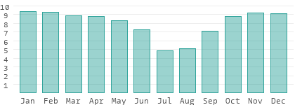
(visible sun, not daylight duration)
Rain days per month
(more than 1 liter/m² and day)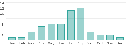
(more than 1 liter/m² and day)
Relative humidity in %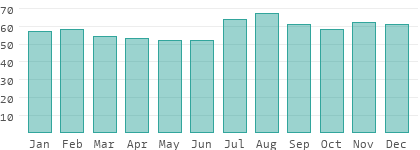
Absolute humidity in g/m³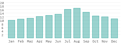
Data basis: German Weather Service, individual values averaged and supplemented by own elements.
Difference between climate and weather
The weather is a snapshot at a specific point in time or over a short period of time. This page deals with the climate on the basis of average values over a long period of time - in our case the past 20 years. In addition, an entire country is covered here on the basis of 2 weather stations, representing not only the major cities but also remote areas at various elevations.