
The climate in Sudan

All climate diagrams on this page come from the collected data of 19 weather stations.
Weather stations at an altitude above 810m have not been included.
All data correspond to the average monthly values of the last 20 years. Country data: Sudan
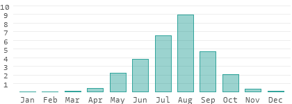
It is warm to hot all year round, inviting bathing at average water temperatures of 28 degrees. The warmest and rainiest part of the country is River Nile. The coldest is Western Darfur. Because of the lower temperatures, the best time for traveling is from December to January. Try to avoid the rainy season from June to September. Uncomfortably high humidity becomes annoying from July to September.
(visible sun, not daylight duration)

(more than 1 liter/m² and day)


Regions in Sudan
All figures per year. For detailed climate data click on the name of the region.| Region | Temperature max Ø day | Temperature min Ø night | Sunshine hours | Rainy days | Precipitation |
|---|---|---|---|---|---|
| Al Jazirah | 37.6 °C | 21.0 °C | 3,285 h | 32 | 303 l |
| Al Qadarif | 37.2 °C | 22.5 °C | 3,103 h | 52 | 639 l |
| Blue Nile | 35.9 °C | 21.5 °C | 2,811 h | 59 | 741 l |
| Kassala | 37.5 °C | 22.8 °C | 3,431 h | 23 | 252 l |
| Khartoum | 37.2 °C | 23.8 °C | 3,577 h | 16 | 135 l |
| Northern Darfur | 35.0 °C | 19.1 °C | 3,139 h | 24 | 245 l |
| Northern State | 37.3 °C | 21.5 °C | 3,431 h | 2 | 18 l |
| Red Sea | 34.8 °C | 25.3 °C | 2,738 h | 10 | 69 l |
| River Nile | 38.3 °C | 23.2 °C | 3,322 h | 6 | 69 l |
| Shamal Kurdufan | 35.2 °C | 20.8 °C | 2,993 h | 37 | 423 l |
| Sinnar | 36.9 °C | 20.9 °C | 2,993 h | 43 | 548 l |
| Southern Kordofan | 35.5 °C | 22.2 °C | 2,774 h | 52 | 646 l |
| Western Darfur | 34.4 °C | 18.7 °C | 3,030 h | 41 | 558 l |
| White Nile | 36.4 °C | 22.9 °C | 2,920 h | 28 | 358 l |
Temperature records of the last 74 years
The hottest temperature measured from 1949 to March 2023 was reported by the Dongola weather station. In June 2010, the record temperature of 49.6 °C was reported here. The hottest meteorological summer from June to August, based on all 26 weather stations in Sudan below 810 meters altitude, was recorded in 2015 with an average temperature of 31.6 °C. This average temperature will normally be measured every four to six hours, thus also including the nights. Normally, this value is 30.0 degrees Celsius. The average maximum daily temperature at that time was 38.0 °C.The coldest day in these 74 years was reported by the Karima weather station. Here the temperature dropped to 1.0 °C in February 2005. Karima lies at an altitude of 249 meters above sea level. The coldest winter (December to February) was in 1983 with an average temperature of 21.1 °C. In Sudan, it is usual to have about 3.7 degrees more at 24.8 °C for this three-month period.
The most precipitation fell in August 2020. With 15.6 mm per day, the Abu Na'ama weather station recorded the highest monthly average of the last 74 years. Incidentally, the region with the most rainfall for the whole year is around Damazine. The driest region is near Wadi Halfa.
Data basis and methodology
The data from the individual measuring stations are based on the archives of the German Weather Service, individual values averaged and supplemented by own elements. In order to determine a representative national average, average values were first calculated for each part of the country, which were then summarized at the national level. Thus, if a disproportionate number of weather stations are located in a small area, their number does not affect the national average.Difference between climate and weather
The weather is a snapshot at a specific point in time or over a short period of time. This page deals with the climate on the basis of average values over a long period of time - in our case the past 20 years. In addition, an entire country is covered here on the basis of 19 weather stations, representing not only the major cities but also remote areas at various elevations.